Andover Tornado - April 29th, 2022
Here's a look at the tornado that struck Andover this evening. https://t.co/pZoaLMwPpa #storm12 #kwch12 #kswx pic.twitter.com/T6cMB0UgAF
— KWCH Eyewitness News (@KWCH12) April 30, 2022
Just days after the anniversary of the 1991 tornado outbreak, Andover
found itself under the gun with an enhanced risk severe weather outlook (3
out of 5 on SPC’s scale) in general Additionally, Andover found themselves
with a 10% tornado risk, with the additional threat that tornadoes that
formed would be strong (EF2 and larger). Elsewhere, the threat level was
as high as 4 out of 5 on the risk scale. ## severe weather set up ###
severe weather outlook the day before and day of The day before at 1:02
am,
the Storm Prediction Center placed Andover in a 10% tornado threat area
with a black hatched area which indicates the additional threat that
tornadoes will be strong (EF2 and greater). The morning of the tornado, at
12:49am,
the SPC continued this risk for Andover and other areas. As of the
outlook issued at
11:19am,
the SPC increased the tornado threat area north of Andover to 15%. Below
is the 11:19 tornado outlook image: 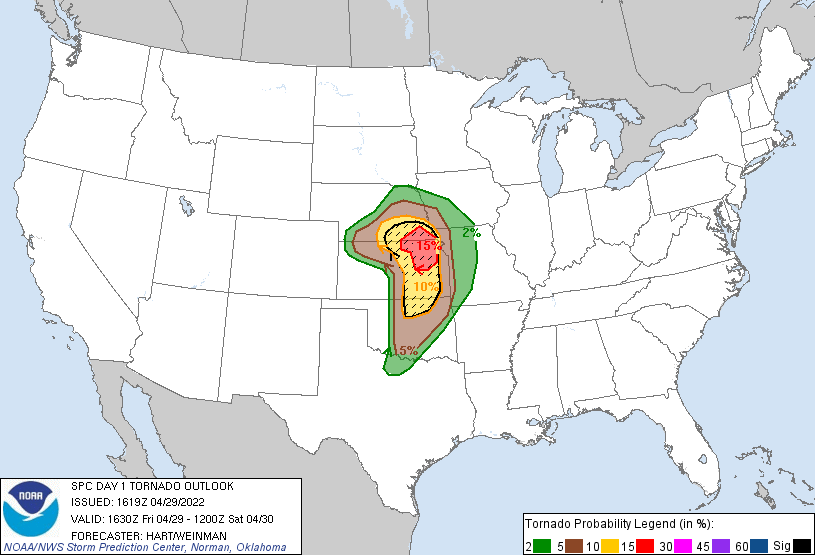
tornado watch #158 - 3:35pm At 3:35pm, the [Storm Prediction
Center][spc] issued tornado watch #158, including the following line: ``` A few tornadoes and a couple intense tornadoes likely
situation", the tornado probabilities were still quite high: ``` PROB OF 2
OR MORE TORNADOES : 70% PROB OF 1 OR MORE STRONG /EF2-EF5/ TORNADOES : 60%
``` [source](https://www.spc.noaa.gov/products/watch/wwp0158.txt) Complete
text of tornado watch #158: ``` URGENT - IMMEDIATE BROADCAST REQUESTED
Tornado Watch Number 158 NWS Storm Prediction Center Norman OK 335 PM CDT
Fri Apr 29 2022 The NWS Storm Prediction Center has issued a * Tornado
Watch for portions of Eastern Kansas Southeast Nebraska * Effective this
Friday afternoon and evening from 335 PM until 1100 PM CDT. * Primary
threats include... A few tornadoes and a couple intense tornadoes likely
Widespread large hail and isolated very large hail events to 3 inches in
diameter likely Widespread damaging wind gusts to 70 mph likely
SUMMARY...Isolated but intense supercell thunderstorms may develop this
afternoon and evening across the watch area. Any storm that forms and
persists will pose a risk of very large hail, damaging winds, and strong
tornadoes. The tornado watch area is approximately along and 70 statute
miles east and west of a line from 30 miles north northwest of Beatrice NE
to 70 miles southeast of Wichita KS. For a complete depiction of the watch
see the associated watch outline update (WOUS64 KWNS WOU8).
PRECAUTIONARY/PREPAREDNESS ACTIONS... REMEMBER...A Tornado Watch means
conditions are favorable for tornadoes and severe thunderstorms in and
close to the watch area. Persons in these areas should be on the lookout
for threatening weather conditions and listen for later statements and
possible warnings. ``` ### NWS Wichita Severe Weather Briefing - 4:19pm In
the 4:19 pm weather briefing, the National Weather Service office in
Wichita, KS included this threat: > However, any storm that forms will
have potential to produce very > large hail, damaging winds, and
tornadoes, some of which could be strong (EF2+). ### Tornado Warning #2
from NWS Wichita - 8:10 pm
[source](https://mesonet.agron.iastate.edu/vtec/?wfo=KICT&phenomena=TO&significance=W&etn=2&year=2022#2022-O-NEW-KICT-TO-W-0002/USCOMP-N0Q-202204300110)
At 8:10pm the NWS forecast office in Wichita issues its second tornado
warning of the year: a tornado warning for Sedgwick (Wichita) and Butler
(Andover) counties: ``` 405 WFUS53 KICT 300110 TORICT KSC015-173-300200-
/O.NEW.KICT.TO.W.0002.220430T0110Z-220430T0200Z/ BULLETIN - EAS ACTIVATION
REQUESTED Tornado Warning National Weather Service Wichita KS 810 PM CDT
Fri Apr 29 2022 The National Weather Service in Wichita has issued a *
Tornado Warning for... East central Sedgwick County in south central
Kansas... Western Butler County in south central Kansas... * Until 900 PM
CDT. * At 810 PM CDT, a severe thunderstorm capable of producing a tornado
was located near Andover, moving northeast at 20 mph. HAZARD...Tornado and
half dollar size hail. SOURCE...Radar indicated rotation. IMPACT...Flying
debris will be dangerous to those caught without shelter. Mobile homes
will be damaged or destroyed. Damage to roofs, windows, and vehicles will
occur. Tree damage is likely. * This dangerous storm will be near...
Andover around 825 PM CDT. Augusta and Benton around 840 PM CDT. Towanda
around 855 PM CDT. El Dorado around 900 PM CDT. Other locations impacted
by this tornadic thunderstorm include El Dorado Airport, Santa Fe Lake and
Augusta Municipal Airport. This includes Interstate 35 between Mile
Markers 47 and 74. PRECAUTIONARY/PREPAREDNESS ACTIONS... TAKE COVER NOW!
Move to a basement or an interior room on the lowest floor of a sturdy
building. Avoid windows. If you are outdoors, in a mobile home, or in a
vehicle, move to the closest substantial shelter and protect yourself from
flying debris. && LAT...LON 3753 9715 3767 9730 3796 9694 3772 9673
TIME...MOT...LOC 0110Z 232DEG 19KT 3763 9718 TORNADO...RADAR INDICATED MAX
HAIL SIZE...1.25 IN $$ KETCHAM ``` At 8:13pm, the tornado warning was
upgraded to confirmed/observed status: ``` At 813 PM CDT, a confirmed
tornado was located near Andover, moving northeast at 20 mph. ``` ## Reed
Timmer footage
<blockquote class="twitter-tweet">
<p lang="en" dir="ltr">
More extreme close-range footage of destructive <a href="https://twitter.com/hashtag/tornado?src=hash&ref_src=twsrc%5Etfw">#tornado
</a> going through Andover Ks. Had bird in the air, attempted to deploy
pressure and tornado was on top of me. Went from 10 to 300 mph in seconds
<a href="https://t.co/Faxnz3vaX8">pic.twitter.com/Faxnz3vaX8</a>
</p>— Reed Timmer (@ReedTimmerAccu) <a href="https://twitter.com/ReedTimmerAccu/status/1520231284102021125?ref_src=twsrc%5Etfw">April 30, 2022
</a>
</blockquote><script async src="https://platform.twitter.com/widgets.js" charset="utf-8"></script>
Approximate location of the start of this shot:
<iframe src="https://www.google.com/maps/embed?pb=!4v1651293129481!6m8!1m7!1sfmE5VRcNhCYiA_xlwzbxcA!2m2!1d37.67815700657006!2d-97.13365637963769!3f109.70223356130145!4f6.332123642783699!5f0.7820865974627469" width="600" height="450" style="border:0;" allowfullscreen="" loading="lazy" referrerpolicy="no-referrer-when-downgrade"></iframe>
## the YMCA in Andover that took damage
<blockquote class="twitter-tweet">
<p lang="en" dir="ltr">
The Andover YMCA has a lot of damage. I sent a note to <a href="https://twitter.com/YMCAWichita?ref_src=twsrc%5Etfw">@ymcawichita
</a> to see if they have anything they can tell us. We have crews gathering
info & will have details on <a href="https://twitter.com/KAKEnews?ref_src=twsrc%5Etfw">@KAKENews
</a> tonight & Good Morning Kansas at 6 & 8 a.m. Saturday. I hope
nobody was hurt.<a href="https://twitter.com/hashtag/KAKENews?src=hash&ref_src=twsrc%5Etfw">#KAKENews
</a>
<a href="https://twitter.com/hashtag/kswx?src=hash&ref_src=twsrc%5Etfw">#kswx
</a>
<a href="https://t.co/oGDnBKkKL5">pic.twitter.com/oGDnBKkKL5</a>
</p>— Annette Lawless KAKE 🌻 (@AnnetteLawless) <a href="https://twitter.com/AnnetteLawless/status/1520225272322269185?ref_src=twsrc%5Etfw">April 30, 2022
</a>
</blockquote><script async src="https://platform.twitter.com/widgets.js" charset="utf-8"></script><blockquote class="twitter-tweet">
<p lang="en" dir="ltr">
<a href="https://twitter.com/hashtag/KSWX?src=hash&ref_src=twsrc%5Etfw">#KSWX
</a>
<a href="https://twitter.com/hashtag/BREAKING?src=hash&ref_src=twsrc%5Etfw">#BREAKING
</a> ***EXPLICIT LANGUAGE WARNING***: A viewer shared this video with us
capturing the aftermath of damage at the Andover YMCA. <a href="https://twitter.com/hashtag/KAKENews?src=hash&ref_src=twsrc%5Etfw">#KAKENews
</a>
<a href="https://t.co/tOPE0yB6K3">pic.twitter.com/tOPE0yB6K3</a>
</p>— Johnathon Hayes KAKE (@JohnHayesNews) <a href="https://twitter.com/JohnHayesNews/status/1520233216627691522?ref_src=twsrc%5Etfw">April 30, 2022
</a>
</blockquote><script async src="https://platform.twitter.com/widgets.js" charset="utf-8"></script><iframe src="https://www.google.com/maps/embed?pb=!1m18!1m12!1m3!1d5324.59258165031!2d-97.12335700000001!3d37.6785663!2m3!1f0!2f0!3f0!3m2!1i1024!2i768!4f13.1!3m3!1m2!1s0x87bafecd7a89c68b%3A0x100b75ec31303a30!2sDr.%20Jim%20Farha%20ANDOVER%20YMCA%20-%20Greater%20Wichita%20YMCA!5e1!3m2!1ses-419!2sus!4v1651292907902!5m2!1ses-419!2sus" width="600" height="450" style="border:0;" allowfullscreen="" loading="lazy" referrerpolicy="no-referrer-when-downgrade"></iframe>
## storm report map for April 29th, 2022 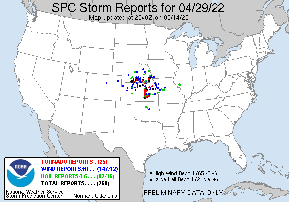 ## more
information - [NWS Wichita](https://www.weather.gov/ict/) - the local
weather forecast office responsible for Andover's area and the office that
will be carrying out the tornado damage assessment that will determine the
Fujita rating for this tornado Several twitter accounts from local TV
stations have been posting footage and imagery from the damage: - [KWCH TV
in Wichita twitter](https://twitter.com/KWCH12) - [KAKE news in Wichita
twitter](https://twitter.com/KAKEnews) - [KSN news in Wichita
twitter](https://twitter.com/KSNNews) General severe weather info: -
[tornado hq](https://www.tornadohq.com) - [severe weather
outlook](https://www.severeweatheroutlook.com) ## to be continued....
[spc]: https://www.spc.noaa.gov